El Nino Stifles Atlantic as Hurricane Season Sets Record Slow Pace
The Atlantic hurricane season is at a record slow pace due to a powerful El Nino, with no hurricanes formed yet and activity at just 7% of normal.
The Atlantic hurricane season is off to an unprecedented slow start, with no hurricanes yet forming and none expected for at least another week, even as the season typically reaches its peak. Only five weak and short-lived tropical storms have developed so far, according to the National Hurricane Center.
On Saturday, the season set a record for the longest stretch without a hurricane — defined as a storm with winds of at least 64 mph — since the satellite era began, said Nick Novella, a meteorologist at the Weather Prediction Center. While a few years before the 1950s saw no hurricanes this late, those records are considered unreliable because ocean monitoring was incomplete.
Overall hurricane activity, measured by the number, strength and duration of storms, is at its lowest level since 1950, according to Phil Klotzbach, a hurricane expert at Colorado State University. Atlantic storm activity is only 7% of normal for this time of year.
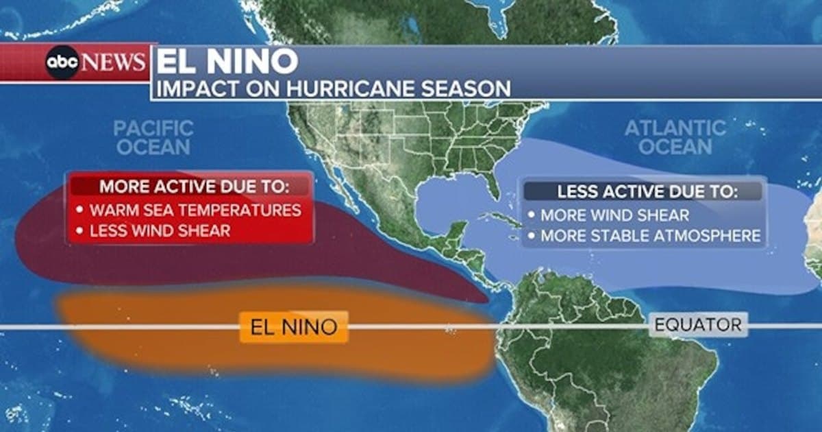
Experts attribute the quiet to a powerful El Nino, the periodic warming of the equatorial Pacific that disrupts weather patterns worldwide. "It's just hammering the Atlantic. It's just impressive," Klotzbach said. "We haven't even had anything really even close to a hurricane."
The main factor is record-strong wind shear, which occurs when strong easterly winds at low levels clash with strong westerly winds at higher altitudes, tearing storms apart. Kristen Corbosiero, an atmospheric science professor at the University at Albany, said wind shear in the region between Africa and the Caribbean — where the strongest storms typically form — is about 45 mph higher than what a tropical cyclone can survive. "Their heads are cut off before they even have a chance," said Brian McNoldy, a hurricane expert at the University of Miami.
Dry air, African dust and fewer storm "seeds" are also suppressing development, while high pressure pushes air downward, further hindering storm formation. These are classic El Nino effects, experts said.
The suppression comes despite unusually warm ocean waters, which normally fuel hurricanes. The world's oceans have been at record heat for 100 days, but El Nino's influence has overwhelmed that warmth. Kerry Emanuel, a meteorology professor at MIT, explained that the temperature difference between the air and the ocean matters more than water temperature alone; because hurricanes are powered by heat flowing from ocean to air, a larger difference reduces storm activity.
Emanuel added that Atlantic waters lag a few months behind the atmosphere in feeling El Nino's effects. As El Nino weakens next year and the atmosphere cools toward normal, the warm water will persist, raising the odds of a busier season.
While the Atlantic remains quiet, the Pacific is bustling. El Nino typically boosts tropical cyclone activity there, with moist air and low wind shear. So far this year, eastern Pacific storm activity is nearly double normal, with hurricanes lasting longer than usual, and central Pacific activity is about 40% above normal. There have been 16 named storms in the eastern Pacific and 20 in the central Pacific, compared with just five in the Atlantic. Hawaii has been hit twice.
Forecasters had predicted a slow Atlantic season months ago because of El Nino's known effects, but the extent of the quiet has surprised some. "I don't think anyone really foresaw it being this quiet," McNoldy said. "This is quite remarkable."
Experts warn that people should not let their guard down, noting that it takes only one storm to cause catastrophe. They pointed to 1992, when Hurricane Andrew formed late but caused devastating damage.